
WLCT hosted Leila Oliveira, a student Bristol Community College, in the fall of 2025 for a semester-long project-based learning experience. Her work focused on wetlands conservation. You can read her Wetlands Primer here.
During my time as an intern for the WLT, I was assigned three separate but similar projects,
each utilizing skills like measuring and analyzing wetland regions and species. Two assignments focused on measuring wetlands by identifying indicator species and GPS measurements. The data collected will be used to develop bridges that account for seasonal flooding, allowing for year-round use. The last project focuses on a bioswale located in the bottom right corner of a large field, which is directly connected to Angeline Brook, allowing runoff and debris to flow into the brook. My task is to identify native plants that can be planted in the bioswale to help prevent pollution.
I gathered this data by comparing FEMA and other governmental mapping tools with my field observations. This allowed me to develop a more accurate understanding of where wetlands and flood zones begin and end. Additionally, I utilized my knowledge and resources to identify native plant species, focusing on the presence of specific wetland indicator plants such as American bur-reed and hop sedge.
The first bridge I measured for was intended for the newly purchased undeveloped land
adjacent to an existing trail from the Conservation. This land features a complex mix of deep wetlands and uplands that intersect one another. This land features a complex mix of deep wetlands and uplands that intersect each other. However, the main flooding occurs in areas with a high concentration of wetlands, particularly where large rocks are present.
The last two bridges I measured for were at the Herb Hadfield property, which features an established trail system near Angeline Brook. Due to this proximity, some areas of the trail are wetlands and prone to flooding.

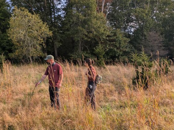
This photo shows the degradation to habitat that occurs on wetland trails. Data that illustrates where wetland and upland intersect will be used to site bridges that span fragile wetland habitat.
I distinguished this by the indicator species, stinging nettle and hop sedge, which were present before and after the bridge location for 15 ft before shifting into upland species like Indian cucumber and rambler rose.

Wetlands Working to Reduce Runoff
The final project was a bioswale located along the bottom of a large field, previously farmed for corn but now preserved and used for growing alfalfa and cover crops. The bioswale is connected to the Angeline Brook and its network of cold water streams, serving to mitigate sediment and general pollution runoff. I was responsible for selecting the most suitable native wetland species to be introduced into and around the bioswale, aiming to decelerate water flow and minimize runoff. My selection comprised four native wetland species: Carex lurida (sallow sedge), Carex aquatilis (water sedge), Alisma triviale (Northern water-plantain), and Juncus nodosus (knotted rush).
This photo shows the alfalfa field to the left of the waterway and carex and other water plants on the right.

I chose all four of these wetland species for the bioswale because, interplanted together, they foster a biodiverse and ecologically strong system. The root network would be woven together through the seasons, creating a carpet underground to halt erosion and other issues consistent with this location.
Plants Serve Multiple Purposes
Carex lurida can thrive in a wide range of moisture conditions and withstands erosion, deer, and sunlight. This adaptability makes it ideal for various locations along the bioswale, as it helps to slow down water movement and reduce erosion once the root system is fully established.
Carex aquatilis was chosen for its minimal maintenance needs, deer resistance, and ability to endure erosion and sunlight. This species would be placed centrally within the swale, as it requires consistently moist soil, unlike Carex lurida. Carex aquatilis serves as a crucial food source for larger waterfowl and provides a moderate food supply for smaller mammals. The objective would be to establish a dense growth of both Carex varieties in the swale, forming a robust root system that significantly slows down water movement and erosion in various locations.
Alisma triviale is recognized for its ability to tolerate disturbances and withstand drought conditions better than many other aquatic plants. Additionally, muskrats and various other aquatic wildlife rely on Alisma triviale as a food source. This species is an excellent choice for areas that lack year-round water, and also contributes to biodiversity by providing food for wildlife.
Juncus nodosus is the last species I chose because it thrives during the spring and fall when soil temperatures are cooler. Additionally, Juncus nodosus is self-seeding and can endure droughts, flooding, and various disturbances. Various birds and mammals eat the seeds produced, while muskrats feed on the rootstalks.
Each of these assignments is distinct and holds significant value for the WLT and the
ecosystem. For the community, the construction of bridges along both new and existing trails will encourage increased year-round usage, complemented by the addition of bog bridges and more resilient structures. The integration of the four selected wetland species into the bioswale adjacent to Angeline Brook is intended to slow water flow and reduce runoff.
Leila worked with Land Steward Nate McCullin during the fall semester, 2025. A passionate gardener and wetlands enthusiast, Leila was completing her work at Bristol Community College. You can read more about Leila here.